Event-ID: ev111109205533
09 November 2011 (313) Greece
Location estimate (+/- standard deviation)
Origin time 20:55:51.3 +/- 0.2 sec
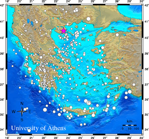
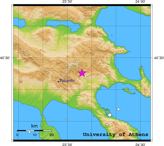
Latitude 40.42 N +/- 2.0 km
Longitude 23.60 E +/- 2.3 km
Depth 10.0 km (fixed)
Magnitudes:
ML=0.0 (0) ml=2.2 (24) mB=0.0 (0)
Median=2.1 (24)
90-Percent confidence region ellipse:
Semi-major axis 16.3 km strike: 91.8 deg
Semi-minor axis 14.1 km
Origin time error 1.2 sec
Autoloc alert ev111109205533: determined by 24 stations
LocSAT solution (with start solution, 24 stations used, weight 24):
Greece ml=2.2 2011/11/09 20:55:51 40.42 N 23.60 E 10 km
Stat Net Date Time Amp Per Res Dist Az ml ML mB
PLG HL 11/11/09 20:55:54.1 745.9 0.5 -1.2 0.1 247 3.3 0.0 0.0
OUR HT 11/11/09 20:55:55.4 228.6 0.3 -2.6 0.3 108 3.1 0.0 0.0
SOH HT 11/11/09 20:55:59.0 59.6 0.6 -1.1 0.4 335 2.3 0.0 0.0
PAIG HT 11/11/09 20:55:59.5 74.6 0.5 -1.5 0.5 173 2.5 0.0 0.0
HORT HT 11/11/09 20:56:00.4 56.4 0.6 0.5 0.4 294 2.3 0.0 0.0
SRS HT 11/11/09 20:56:03.0 60.9 0.6 -1.2 0.7 359 2.4 0.0 0.0
GRG HT 11/11/09 20:56:06.8 46.2 0.3 -3.3 1.1 301 2.7 0.0 0.0
KNT HT 11/11/09 20:56:07.5 25.0 0.5 -0.2 0.9 324 2.2 0.0 0.0
NVR HL 11/11/09 20:56:08.0 33.4 0.8 -0.3 0.9 12 2.2 0.0 0.0
LIT HT 11/11/09 20:56:08.7 18.5 0.8 0.9 0.9 249 1.9 0.0 0.0
THE HT 11/11/09 20:56:08.8 28.0 0.7 7.2 0.5 293 2.0 0.0 0.0
XOR HT 11/11/09 20:56:11.6 15.5 0.6 0.8 1.1 197 2.0 0.0 0.0
FYTO HA 11/11/09 20:56:11.7 41.4 0.9 0.4 1.1 207 2.3 0.0 0.0
NEO HL 11/11/09 20:56:12.1 74.0 0.5 0.5 1.2 195 2.8 0.0 0.0
SKIA HA 11/11/09 20:56:14.0 11.1 0.6 0.7 1.3 185 2.0 0.0 0.0
LIA HL 11/11/09 20:56:16.2 7.9 1.0 1.9 1.3 113 1.7 0.0 0.0
THL HL 11/11/09 20:56:17.5 7.2 0.9 0.4 1.5 235 1.7 0.0 0.0
SMTH HL 11/11/09 20:56:18.5 10.6 1.5 1.8 1.5 88 1.7 0.0 0.0
RDO HL 11/11/09 20:56:19.6 2.3 0.5 0.3 1.6 63 1.6 0.0 0.0
SMIA HA 11/11/09 20:56:20.6 60.7 0.7 2.3 1.6 191 2.8 0.0 0.0
UPR HP 11/11/09 20:56:21.6 0.8 0.6 -11.2 2.6 214 1.6 0.0 0.0
VILL HA 11/11/09 20:56:29.1 3.0 1.8 0.3 2.3 186 1.5 0.0 0.0
KALE HA 11/11/09 20:56:29.6 6.9 1.7 0.0 2.3 210 1.9 0.0 0.0
KLV HL 11/11/09 20:56:38.3 4.0 2.2 4.5 2.6 206 1.7 0.0 0.0
RMS-ERR: 1.64
First location: 2011/11/09 20:57:40 UTC
This location: 2011/11/09 20:57:40 UTC
|