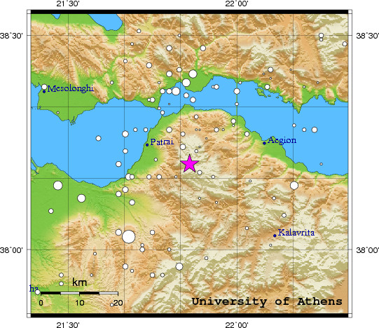
 Event-ID:    ev110906153730

 06 September 2011   (249)             Greece

 Location estimate (+/- standard deviation)
  Origin time       15:37:38.2  +/-   0.3 sec
  Latitude           38.20 N    +/-   3.1 km
  Longitude          21.86 E    +/-   3.4 km
  Depth              10.0  km   (fixed)

 Magnitudes:
  ML=0.0 (0)  ml=2.0 (14)  mB=0.0 (0)
  Median=1.7 (14)

 90-Percent confidence region ellipse:
  Semi-major axis     31.7 km  strike: 124.2 deg
  Semi-minor axis     24.9 km
  Origin time error    2.2 sec

 Autoloc alert ev110906153730: determined by 14 stations

 LocSAT solution (with start solution, 14 stations used, weight 14):

  Greece  ml=2.0  2011/09/06  15:37:38  38.20 N  21.86 E   10 km

  Stat  Net   Date       Time          Amp    Per   Res  Dist  Az ml  ML  mB
  LAKA  HA  11/09/06  15:37:39.5        32.9  1.2  -2.0   0.1  67 1.6 0.0 0.0
  TRIZ  HA  11/09/06  15:37:39.6        14.1  1.0  -4.1   0.2  45 1.4 0.0 0.0
  SERG  HP  11/09/06  15:37:39.8        75.2  0.9  -4.4   0.3  36 2.1 0.0 0.0
  UPR   HP  11/09/06  15:37:39.8         2.9  0.6  -2.0   0.1 324 0.8 0.0 0.0
  RLS   HL  11/09/06  15:37:40.0         5.9  2.0  -5.6   0.3 245 0.7 0.0 0.0
  PYRG  HA  11/09/06  15:37:40.2         0.7  0.4  -3.7   0.2  30 0.4 0.0 0.0
  KLV   HL  11/09/06  15:37:42.6         4.5  1.7  -1.6   0.3 125 0.7 0.0 0.0
  DRO   HP  11/09/06  15:37:50.1        11.7  0.4   5.8   0.3 206 1.7 0.0 0.0
  EVR   HL  11/09/06  15:37:54.4         9.2  0.9   2.8   0.7 357 1.5 0.0 0.0
  SNT2  HA  11/09/06  15:38:29.9        93.6  0.6  -1.0   3.4 122 4.0 0.0 0.0
  SMTH  HL  11/09/06  15:38:34.8       165.6  0.7   0.4   3.6  50 4.3 0.0 0.0
  SRS   HT  11/09/06  15:38:35.7         7.6  1.0   7.2   3.2  24 2.6 0.0 0.0
  ALN   HT  11/09/06  15:38:43.8        14.5  0.8   1.6   4.2  49 3.5 0.0 0.0
  RDO   HL  11/09/06  15:38:47.1         4.8  0.8   6.5   4.1  43 2.9 0.0 0.0

 RMS-ERR:         2.15

 First location:  2011/09/06 15:55:52 UTC
 This location:   2011/09/06 15:55:53 UTC
|