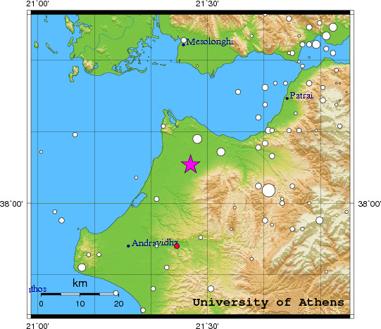
 Event-ID:    ev110906034547

 06 September 2011   (249)             Greece

 Location estimate (+/- standard deviation)
  Origin time       03:45:45.7  +/-   0.2 sec
  Latitude           38.09 N    +/-   2.1 km
  Longitude          21.45 E    +/-   2.0 km
  Depth              10.0  km   (fixed)

 Magnitudes:
  ML=0.0 (0)  ml=2.1 (28)  mB=0.0 (0)
  Median=2.1 (28)

 90-Percent confidence region ellipse:
  Semi-major axis     18.9 km  strike: 36.0 deg
  Semi-minor axis     15.9 km
  Origin time error    1.4 sec

 Autoloc alert ev110906034547: determined by 28 stations

 LocSAT solution (with start solution, 28 stations used, weight 28):

  Greece  ml=2.1  2011/09/06  03:45:45  38.09 N  21.45 E   10 km

  Stat  Net   Date       Time          Amp    Per   Res  Dist  Az ml  ML  mB
  RLS   HL  11/09/06  03:45:47.5        39.3  0.8  -0.7   0.0 159 1.8 0.0 0.0
  DRO   HP  11/09/06  03:45:48.0        76.2  0.6  -3.6   0.2 124 2.3 0.0 0.0
  EVR   HL  11/09/06  03:45:49.0        14.1  1.0 -12.4   0.9  19 1.7 0.0 0.0
  AXS   HP  11/09/06  03:45:49.7       203.3  0.5   0.2   0.1 331 2.7 0.0 0.0
  VTN   HP  11/09/06  03:45:53.6        53.9  0.3   1.7   0.3 230 2.5 0.0 0.0
  KLV   HL  11/09/06  03:45:53.6        20.2  0.6  -2.8   0.6  95 1.9 0.0 0.0
  LAKA  HA  11/09/06  03:45:53.7       109.5  0.7  -0.9   0.4  70 2.5 0.0 0.0
  TRIZ  HA  11/09/06  03:45:56.1        13.6  0.3  -0.4   0.6  61 2.0 0.0 0.0
  SERG  HP  11/09/06  03:45:56.2        82.5  0.2  -0.6   0.6  56 2.9 0.0 0.0
  ALIK  HA  11/09/06  03:45:56.5         2.1  0.4   0.1   0.5  72 1.1 0.0 0.0
  PSAR  HA  11/09/06  03:45:56.8        60.9  0.4  -0.6   0.6  67 2.6 0.0 0.0
  PDO   HP  11/09/06  03:45:56.8        19.9  0.3   0.5   0.5 338 2.2 0.0 0.0
  VLS   HL  11/09/06  03:45:56.9        13.2  0.7  -1.6   0.7 277 1.7 0.0 0.0
  KALE  HA  11/09/06  03:45:56.9        26.4  0.5  -0.6   0.6  61 2.1 0.0 0.0
  PYRG  HA  11/09/06  03:45:57.8         1.3  0.4   1.5   0.5  54 0.9 0.0 0.0
  TRIP  HA  11/09/06  03:45:58.2       125.5  0.4  -3.1   0.9 131 3.0 0.0 0.0
  KFL   HP  11/09/06  03:45:58.8        20.5  0.8   2.9   0.5 272 1.8 0.0 0.0
  ITM   HL  11/09/06  03:45:59.9        23.0  0.7  -3.4   1.0 157 2.1 0.0 0.0
  UPR   HP  11/09/06  03:46:01.6         4.9  0.7   8.9   0.3  54 1.1 0.0 0.0
  VLX   HP  11/09/06  03:46:03.2        23.0  0.6  -0.8   1.0 134 2.2 0.0 0.0
  LKD2  HT  11/09/06  03:46:04.0        45.6  0.8   1.5   0.9 319 2.3 0.0 0.0
  PROD  HA  11/09/06  03:46:08.8         3.6  1.0   2.8   1.2  81 1.2 0.0 0.0
  LTK   HP  11/09/06  03:46:08.8         9.1  1.3   2.1   1.2  93 1.5 0.0 0.0
  DID   HP  11/09/06  03:46:12.2        29.4  0.8   0.2   1.5 112 2.4 0.0 0.0
  THL   HL  11/09/06  03:46:17.8         3.1  0.8   5.8   1.5  16 1.4 0.0 0.0
  VLI   HL  11/09/06  03:46:24.6         7.7  2.1   8.0   1.8 139 1.6 0.0 0.0
  ANKY  HL  11/09/06  03:46:27.5        33.7  1.6  -1.2   2.7 146 2.8 0.0 0.0
  TIR   MN  11/09/06  03:46:36.1         6.7  0.4  -3.5   3.5 340 3.0 0.0 0.0

 RMS-ERR:         1.97

 First location:  2011/09/06 03:56:13 UTC
 This location:   2011/09/06 03:56:14 UTC
|