Event-ID: ev110820144034
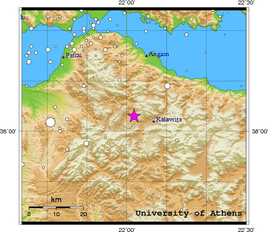
20 August 2011 (232) Greece
Location estimate (+/- standard deviation)
Origin time 14:40:35.8 +/- 0.5 sec
Latitude 38.05 N +/- 4.1 km
Longitude 22.03 E +/- 2.9 km
Depth 10.0 km (fixed)
Magnitudes:
ML=0.0 (0) ml=1.9 (15) mB=0.0 (0)
Median=1.7 (15)
90-Percent confidence region ellipse:
Semi-major axis 28.4 km strike: 2.6 deg
Semi-minor axis 20.3 km
Origin time error 2.4 sec
Autoloc alert ev110820144034: determined by 15 stations
LocSAT solution (with start solution, 15 stations used, weight 15):
Greece ml=1.9 2011/08/20 14:40:35 38.05 N 22.03 E 10 km
Stat Net Date Time Amp Per Res Dist Az ml ML mB
KLV HL 11/08/20 14:40:34.7 13.6 0.7 -4.3 0.1 91 1.4 0.0 0.0
VVK HP 11/08/20 14:40:40.1 179.3 0.3 -4.3 0.4 336 3.1 0.0 0.0
UPR HP 11/08/20 14:40:40.2 15.8 0.6 -2.3 0.3 321 1.6 0.0 0.0
LAKA HA 11/08/20 14:40:41.4 103.0 0.6 0.4 0.2 348 2.5 0.0 0.0
TRIZ HA 11/08/20 14:40:42.6 24.1 0.9 -0.3 0.3 6 1.7 0.0 0.0
SERG HP 11/08/20 14:40:42.6 101.3 0.3 -1.0 0.4 3 2.8 0.0 0.0
PYRG HA 11/08/20 14:40:42.8 1.9 0.3 -0.7 0.4 358 1.0 0.0 0.0
KALE HA 11/08/20 14:40:43.5 22.7 0.8 0.1 0.4 14 1.7 0.0 0.0
PSAR HA 11/08/20 14:40:43.9 61.5 0.8 1.3 0.3 22 2.1 0.0 0.0
RLS HL 11/08/20 14:40:44.8 6.3 0.3 0.3 0.4 272 1.6 0.0 0.0
AXS HP 11/08/20 14:40:45.5 41.2 0.9 -0.6 0.5 287 2.1 0.0 0.0
PDO HP 11/08/20 14:40:49.3 15.6 0.3 -2.2 0.9 310 2.3 0.0 0.0
EPID HA 11/08/20 14:40:55.4 20.6 2.0 2.8 1.0 116 1.6 0.0 0.0
VLS HL 11/08/20 14:40:57.7 11.4 1.4 2.1 1.1 277 1.6 0.0 0.0
EVR HL 11/08/20 14:41:00.6 13.4 1.3 8.7 0.9 349 1.5 0.0 0.0
RMS-ERR: 1.52
First location: 2011/08/20 14:48:23 UTC
This location: 2011/08/20 14:48:24 UTC
|