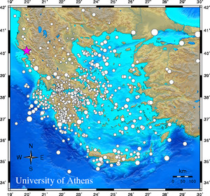
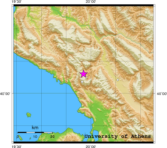
 Event-ID:    ev110729164121

 29 July 2011   (210)                  Albania

 Location estimate (+/- standard deviation)
  Origin time       16:41:18.6  +/-   0.4 sec
  Latitude           40.10 N    +/-   2.8 km
  Longitude          19.95 E    +/-   3.6 km
  Depth              10.0  km   (fixed)

 Magnitudes:
  ML=0.0 (0)  ml=2.8 (23)  mB=0.0 (0)
  Median=2.7 (23)

 90-Percent confidence region ellipse:
  Semi-major axis     40.7 km  strike: 107.7 deg
  Semi-minor axis     29.4 km
  Origin time error    3.3 sec

 Autoloc alert ev110729164121: determined by 24 stations

 LocSAT solution (with start solution, 24 stations used, weight 24):

  Albania  ml=2.8  2011/07/29  16:41:18  40.10 N  19.95 E   10 km

  Stat  Net   Date       Time          Amp    Per   Res  Dist  Az ml  ML  mB
  KEK   HL  11/07/29  16:41:21.7       601.4  0.8  -5.2   0.4 196 3.2 0.0 0.0
  SGD   HP  11/07/29  16:41:24.1      1017.8  1.2  -5.0   0.5 156 3.3 0.0 0.0
  IGT   HT  11/07/29  16:41:27.2       262.5  1.0  -3.5   0.6 152 2.8 0.0 0.0
  FNA   HT  11/07/29  16:41:34.7       155.2  1.0  -6.3   1.3  58 3.0 0.0 0.0
  TIR   MN  11/07/29  16:41:40.0        92.5  1.0  -0.3   1.2 357 2.7 0.0 0.0
  KZN   HL  11/07/29  16:41:40.7       137.0  1.0  -2.4   1.4  81 2.9 0.0 0.0
  RLS   HL  11/07/29  16:41:42.7        22.3  1.7 -14.6   2.4 149 2.4 0.0 0.0
  LKD2  HT  11/07/29  16:41:44.6       188.9  0.9   1.4   1.4 157 3.1 0.0 0.0
  THL   HL  11/07/29  16:41:45.1        30.3  0.7  -2.2   1.7 108 2.6 0.0 0.0
  PDO   HP  11/07/29  16:41:48.2        37.7  0.8  -0.7   1.8 147 2.6 0.0 0.0
  LIT   HT  11/07/29  16:41:48.8        43.9  1.0  -2.8   1.9  89 2.7 0.0 0.0
  EVR   HL  11/07/29  16:41:51.4        65.5  0.8   1.2   1.9 129 2.9 0.0 0.0
  VLS   HL  11/07/29  16:41:54.0        24.1  0.9   1.8   2.0 165 2.5 0.0 0.0
  KNT   HT  11/07/29  16:41:55.0        15.9  0.8  -4.0   2.5  64 2.6 0.0 0.0
  LAKA  HA  11/07/29  16:41:57.5        75.1  1.7  -0.9   2.4 139 3.0 0.0 0.0
  KALE  HA  11/07/29  16:41:58.1        33.6  1.2   0.1   2.4 134 2.7 0.0 0.0
  SERG  HP  11/07/29  16:42:00.7       112.2  1.1   3.5   2.4 135 3.3 0.0 0.0
  KLV   HL  11/07/29  16:42:01.7        22.1  1.6   0.1   2.7 140 2.6 0.0 0.0
  RLS   HL  11/07/29  16:42:03.2        22.3  1.7   5.9   2.4 149 2.4 0.0 0.0
  DRO   HP  11/07/29  16:42:03.8        27.2  1.7   3.9   2.6 147 2.6 0.0 0.0
  TIP   MN  11/07/29  16:42:04.7        29.7  1.1   3.7   2.6 250 2.8 0.0 0.0
  PYRG  HA  11/07/29  16:42:06.1         1.3  0.6   9.2   2.3 136 1.6 0.0 0.0
  SOH   HT  11/07/29  16:42:11.2        12.8  0.7   9.3   2.7  73 2.7 0.0 0.0
  SKIA  HA  11/07/29  16:42:12.3        19.1  1.4   8.0   2.9 108 2.7 0.0 0.0

 RMS-ERR:         2.78

 First location:  2011/07/29 16:47:52 UTC
 This location:   2011/07/29 16:47:52 UTC
|