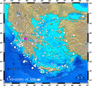
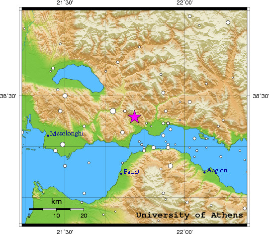
 Event-ID:    ev110131210924

 31 January 2011   (031)               Greece

 Location estimate (+/- standard deviation)
  Origin time       21:09:26.7  +/-   0.2 sec
  Latitude           38.43 N    +/-   2.3 km
  Longitude          21.79 E    +/-   2.3 km
  Depth              10.0  km   (fixed)

 Magnitudes:
  ML=0.0 (0)  ml=1.8 (22)  mB=0.0 (0)
  Median=1.7 (22)

 90-Percent confidence region ellipse:
  Semi-major axis     35.9 km  strike: 41.7 deg
  Semi-minor axis     29.1 km
  Origin time error    2.6 sec

 Autoloc alert ev110131210924: determined by 22 stations

 LocSAT solution (with start solution, 22 stations used, weight 22):

  Greece  ml=1.8  2011/01/31  21:09:26  38.43 N  21.79 E   10 km

  Stat  Net   Date       Time          Amp    Per   Res  Dist  Az ml  ML  mB
  EFP   HP  11/01/31  21:09:24.2       457.4  0.6  -5.8   0.1  90 3.1 0.0 0.0
  RODI  HA  11/01/31  21:09:24.4       183.8  0.7  -6.3   0.1 140 2.6 0.0 0.0
  UPR   HP  11/01/31  21:09:26.2         8.5  0.5  -4.7   0.1 180 1.4 0.0 0.0
  LAKA  HA  11/01/31  21:09:26.2       169.6  0.5  -6.2   0.2 141 2.8 0.0 0.0
  KALE  HA  11/01/31  21:09:27.6        36.1  0.6  -5.5   0.3  97 2.0 0.0 0.0
  PSAR  HA  11/01/31  21:09:28.1         2.0  0.4  -5.6   0.3 107 0.9 0.0 0.0
  PVO   HP  11/01/31  21:09:28.5         0.8  0.3  -4.6   0.3 313 0.7 0.0 0.0
  KLV   HL  11/01/31  21:09:30.3        16.5  0.9  -6.0   0.5 143 1.6 0.0 0.0
  DRO   HP  11/01/31  21:09:30.5        24.6  1.0  -5.7   0.5 187 1.7 0.0 0.0
  RLS   HL  11/01/31  21:09:30.8        11.3  1.1  -4.9   0.4 214 1.3 0.0 0.0
  PDO   HP  11/01/31  21:09:31.7        22.4  0.7  -4.9   0.5 290 1.8 0.0 0.0
  EVR   HL  11/01/31  21:09:34.4        42.4  0.9  -2.0   0.5   2 2.0 0.0 0.0
  DESF  HA  11/01/31  21:09:34.5        15.3  1.0  -3.5   0.6  91 1.6 0.0 0.0
  DSL   HP  11/01/31  21:09:43.2        19.5  1.9   0.4   0.9 323 1.6 0.0 0.0
  GUR   HP  11/01/31  21:09:43.3        12.8  0.3   4.2   0.7 138 2.0 0.0 0.0
  VILL  HA  11/01/31  21:09:48.4         9.1  1.5   0.2   1.2 102 1.5 0.0 0.0
  THAL  HA  11/01/31  21:09:48.6        23.0  1.0   7.3   0.8 119 1.9 0.0 0.0
  THL   HL  11/01/31  21:09:51.8         4.6  1.1   4.9   1.1   9 1.3 0.0 0.0
  VLS   HL  11/01/31  21:09:53.2        20.4  1.6   9.1   1.0 255 1.7 0.0 0.0
  AMT   HP  11/01/31  21:09:54.0        38.9  1.4  11.1   0.9 184 2.0 0.0 0.0
  LKR   HL  11/01/31  21:09:58.0         6.0  1.6  13.8   1.0  76 1.2 0.0 0.0
  TRIP  HA  11/01/31  21:09:58.7       120.6  1.8  14.5   1.0 157 2.4 0.0 0.0

 RMS-ERR:         3.48

 First location:  2011/01/31 21:12:35 UTC
 This location:   2011/01/31 21:12:35 UTC
|