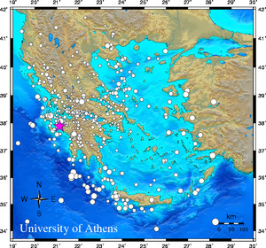
Event-ID: ev110117192233
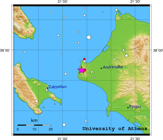
17 January 2011 (017) Southern Greece
Location estimate (+/- standard deviation)
Origin time 19:22:29.5 +/- 0.4 sec
Latitude 37.89 N +/- 2.8 km
Longitude 21.13 E +/- 2.7 km
Depth 10.0 km (fixed)
Magnitudes:
ML=0.0 (0) ml=2.7 (34) mB=0.0 (0)
Median=2.7 (34)
90-Percent confidence region ellipse:
Semi-major axis 27.5 km strike: 42.6 deg
Semi-minor axis 16.0 km
Origin time error 2.3 sec
Autoloc alert ev110117192233: determined by 34 stations
LocSAT solution (with start solution, 34 stations used, weight 34):
Southern Greece ml=2.7 2011/01/17 19:22:29 37.89 N 21.13 E 10 km
Stat Net Date Time Amp Per Res Dist Az ml ML mB
RLS HL 11/01/17 19:22:33.0 142.0 0.6 -3.5 0.3 57 2.7 0.0 0.0
AXS HP 11/01/17 19:22:33.7 711.3 0.8 -3.5 0.4 32 3.3 0.0 0.0
KFL HP 11/01/17 19:22:34.8 270.7 0.8 -2.2 0.3 310 2.8 0.0 0.0
DRO HP 11/01/17 19:22:35.5 251.4 0.6 -3.3 0.5 82 3.0 0.0 0.0
VLS HL 11/01/17 19:22:36.0 218.6 0.4 -3.6 0.5 305 3.1 0.0 0.0
AMT HP 11/01/17 19:22:39.3 471.4 0.7 -1.4 0.6 127 3.2 0.0 0.0
PDO HP 11/01/17 19:22:39.6 188.0 0.4 -3.2 0.7 4 3.1 0.0 0.0
LAKA HA 11/01/17 19:22:40.5 283.0 0.7 -3.0 0.8 62 3.1 0.0 0.0
RODI HA 11/01/17 19:22:40.6 92.4 0.6 -2.7 0.7 54 2.7 0.0 0.0
UPR HP 11/01/17 19:22:41.4 19.4 0.5 -0.5 0.7 52 2.0 0.0 0.0
EFP HP 11/01/17 19:22:41.5 135.6 0.4 -3.0 0.8 48 3.1 0.0 0.0
KALE HA 11/01/17 19:22:43.4 113.5 0.6 -3.1 0.9 57 2.9 0.0 0.0
PSAR HA 11/01/17 19:22:45.1 4.9 0.4 -1.3 0.9 61 1.6 0.0 0.0
PYL HP 11/01/17 19:22:46.8 56.5 0.8 -2.2 1.1 154 2.5 0.0 0.0
EVR HL 11/01/17 19:22:47.7 114.7 0.9 -2.3 1.2 27 2.8 0.0 0.0
TRIP HA 11/01/17 19:22:48.2 499.4 0.7 1.2 1.0 111 3.5 0.0 0.0
DSL HP 11/01/17 19:22:48.7 154.2 1.0 -2.6 1.2 359 2.9 0.0 0.0
DESF HA 11/01/17 19:22:49.6 41.7 0.8 -1.4 1.2 64 2.4 0.0 0.0
MAKR HA 11/01/17 19:22:52.0 81.4 0.8 -1.3 1.4 35 2.8 0.0 0.0
DSF HP 11/01/17 19:22:52.6 47.3 0.7 1.7 1.2 64 2.5 0.0 0.0
THAL HA 11/01/17 19:22:52.8 54.6 0.7 1.8 1.2 82 2.6 0.0 0.0
VLX HP 11/01/17 19:22:52.9 58.3 1.0 3.7 1.1 117 2.4 0.0 0.0
LTK HP 11/01/17 19:22:56.0 69.5 1.3 1.3 1.5 84 2.6 0.0 0.0
LKR HL 11/01/17 19:22:58.0 11.2 1.2 0.1 1.7 62 1.9 0.0 0.0
DID HP 11/01/17 19:22:59.1 123.4 0.8 0.4 1.7 102 3.1 0.0 0.0
THL HL 11/01/17 19:22:59.6 15.0 0.6 -0.6 1.8 22 2.4 0.0 0.0
KRND HT 11/01/17 19:22:59.7 75.1 2.8 1.5 1.7 107 2.4 0.0 0.0
IGT HT 11/01/17 19:22:59.7 21.9 1.0 0.3 1.8 340 2.3 0.0 0.0
VILL HA 11/01/17 19:22:59.8 22.9 1.9 0.5 1.7 80 2.1 0.0 0.0
SGD HP 11/01/17 19:23:01.6 29.2 1.4 0.5 1.9 338 2.4 0.0 0.0
NEST HT 11/01/17 19:23:11.1 8.1 1.2 0.6 2.5 359 2.2 0.0 0.0
NEO HL 11/01/17 19:23:13.0 47.7 1.0 7.4 2.2 48 2.8 0.0 0.0
LIT HT 11/01/17 19:23:19.3 17.4 0.9 9.8 2.5 25 2.6 0.0 0.0
FNA HT 11/01/17 19:23:29.5 8.6 0.6 13.9 2.9 4 2.7 0.0 0.0
RMS-ERR: 2.00
First location: 2011/01/17 19:27:34 UTC
This location: 2011/01/17 19:27:35 UTC
|