Event-ID: ev100713120803
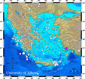
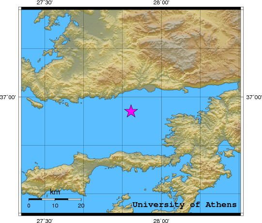
13 July 2010 (194) Dodecanese Islands, Greece
Location estimate (+/- standard deviation)
Origin time 12:07:55.6 +/- 0.3 sec
Latitude 36.95 N +/- 2.5 km
Longitude 27.89 E +/- 2.9 km
Depth 10.0 km (fixed)
Magnitudes:
ML=4.0 (1) ml=3.6 (23) mB=4.1 (1)
Median=3.6 (25)
90-Percent confidence region ellipse:
Semi-major axis 28.2 km strike: 70.6 deg
Semi-minor axis 22.9 km
Origin time error 2.2 sec
Autoloc alert ev100713120803: determined by 36 stations
LocSAT solution (with start solution, 36 stations used, weight 36):
Dodecanese Islands, Greece ml=3.6 2010/07/13 12:07:55 36.95 N 27.89 E 10 km
Stat Net Date Time Amp Per Res Dist Az ml ML mB
NIS1 HT 10/07/13 12:08:03.3 3408.8 0.7 -4.7 0.7 239 4.1 0.0 0.0
NISR HL 10/07/13 12:08:04.0 331.7 0.5 -4.5 0.7 241 3.2 0.0 0.0
ARG HL 10/07/13 12:08:06.1 3865.8 0.7 -3.4 0.8 165 4.2 4.0 4.1
SMG HL 10/07/13 12:08:11.7 1737.0 0.7 -3.6 1.1 313 4.1 0.0 0.0
KARP HL 10/07/13 12:08:17.6 850.9 0.9 -4.0 1.5 203 3.9 0.0 0.0
CHOS HT 10/07/13 12:08:29.0 138.6 0.9 -0.9 2.0 315 3.3 0.0 0.0
SANT GE 10/07/13 12:08:33.2 108.0 1.0 3.4 2.0 254 3.1 0.0 0.0
NPS HL 10/07/13 12:08:34.0 52.5 0.8 -2.1 2.5 228 3.2 0.0 0.0
PRK HL 10/07/13 12:08:34.0 206.1 0.7 -3.8 2.6 332 3.9 0.0 0.0
APE GE 10/07/13 12:08:34.4 212.7 0.8 6.8 1.9 274 3.5 0.0 0.0
ISP GE 10/07/13 12:08:37.4 120.2 0.8 4.4 2.3 66 3.4 0.0 0.0
SIGR HT 10/07/13 12:08:37.5 68.2 0.7 -2.4 2.8 325 3.5 0.0 0.0
KARY HA 10/07/13 12:08:38.7 127.7 1.0 -3.6 2.9 293 3.7 0.0 0.0
EREA HA 10/07/13 12:08:45.8 13.5 0.9 -3.6 3.5 296 3.0 0.0 0.0
LIA HL 10/07/13 12:08:47.7 41.7 0.7 -4.0 3.6 325 3.7 0.0 0.0
AOS HT 10/07/13 12:08:51.9 14.5 0.7 -2.9 3.9 306 3.3 0.0 0.0
VILL HA 10/07/13 12:08:52.1 22.8 0.8 -2.3 3.8 290 3.5 0.0 0.0
SMTH HL 10/07/13 12:08:52.3 23.5 0.6 -4.0 4.0 333 3.7 0.0 0.0
MRKA HA 10/07/13 12:08:53.4 63.4 1.0 -1.0 3.8 299 3.8 0.0 0.0
ALN HT 10/07/13 12:08:55.8 48.6 1.2 -3.4 4.2 341 3.8 0.0 0.0
NEO HL 10/07/13 12:08:58.7 14.6 0.6 -3.0 4.4 304 3.6 0.0 0.0
VLI HL 10/07/13 12:08:59.3 22.7 0.7 3.0 4.0 268 3.6 0.0 0.0
OUR HT 10/07/13 12:09:02.4 0.0 0.0 -2.0 4.6 319 0.0 0.0 0.0
KLV HL 10/07/13 12:09:03.2 0.0 0.0 -3.0 4.7 285 0.0 0.0 0.0
DIDY HA 10/07/13 12:09:08.4 19.9 0.8 14.8 3.8 279 3.4 0.0 0.0
MAKR HA 10/07/13 12:09:10.5 0.0 0.0 0.2 5.0 296 0.0 0.0 0.0
CSS GE 10/07/13 12:09:12.5 0.0 0.0 4.2 4.8 113 0.0 0.0 0.0
THL HL 10/07/13 12:09:13.0 0.0 0.0 -1.6 5.3 301 0.0 0.0 0.0
NVR HL 10/07/13 12:09:13.1 0.0 0.0 -2.7 5.4 326 0.0 0.0 0.0
LAKA HA 10/07/13 12:09:13.3 0.0 0.0 4.7 4.9 287 0.0 0.0 0.0
KALE HA 10/07/13 12:09:13.7 0.0 0.0 6.3 4.8 289 0.0 0.0 0.0
SOH HT 10/07/13 12:09:15.8 0.0 0.0 2.1 5.2 319 0.0 0.0 0.0
RODI HA 10/07/13 12:09:16.4 0.0 0.0 6.7 4.9 288 0.0 0.0 0.0
SRS HT 10/07/13 12:09:19.1 0.0 0.0 4.1 5.3 323 0.0 0.0 0.0
KNT HT 10/07/13 12:09:26.2 0.0 0.0 5.9 5.7 319 0.0 0.0 0.0
TIP MN 10/07/13 12:10:05.5 0.0 0.0 -0.3 9.0 288 0.0 0.0 0.0
RMS-ERR: 2.55
First location: 2010/07/13 12:11:05 UTC
This location: 2010/07/13 12:11:06 UTC
|