![]()
|
|

2011 11 March 05:46:23 UTC
Preliminary Slip model of the
Mw9 Tohoku Honshu Japan Earthquake
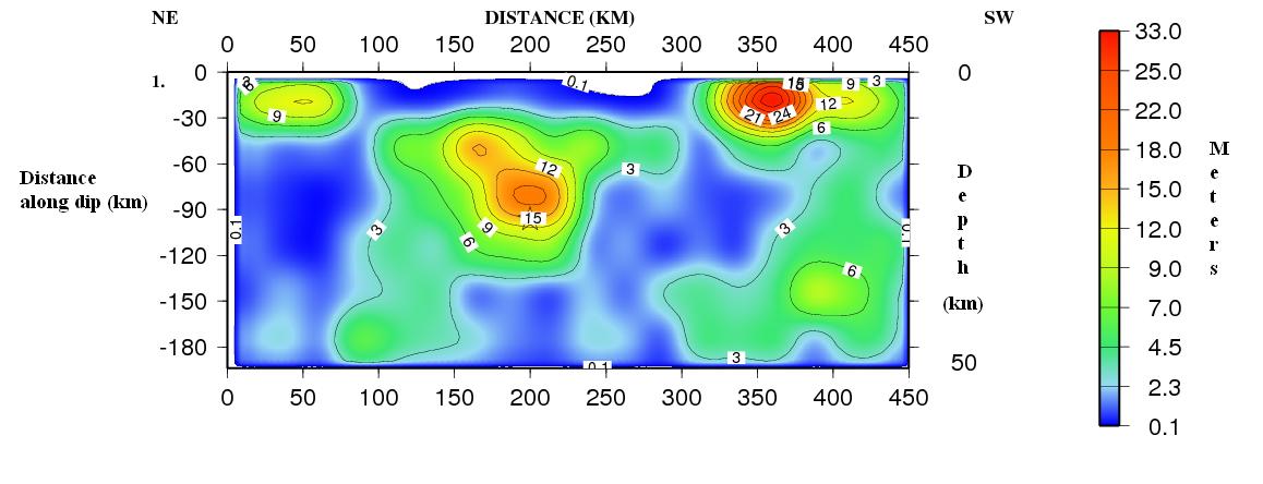
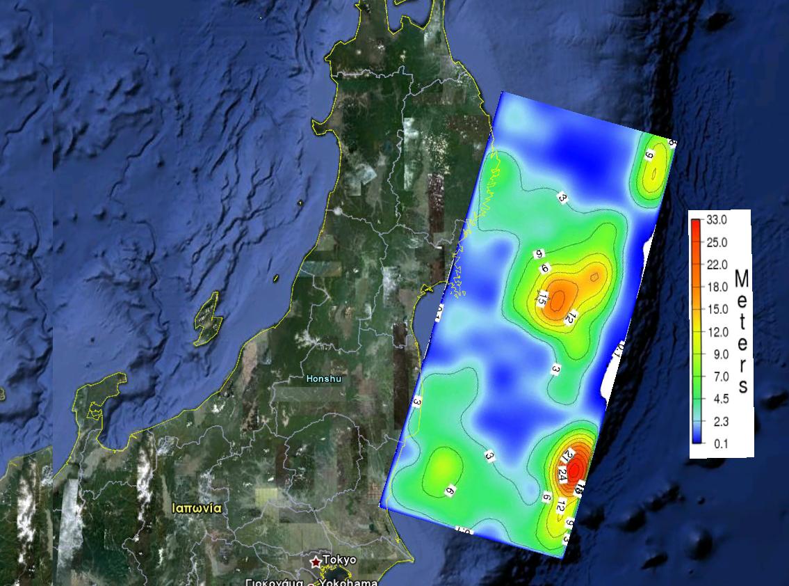
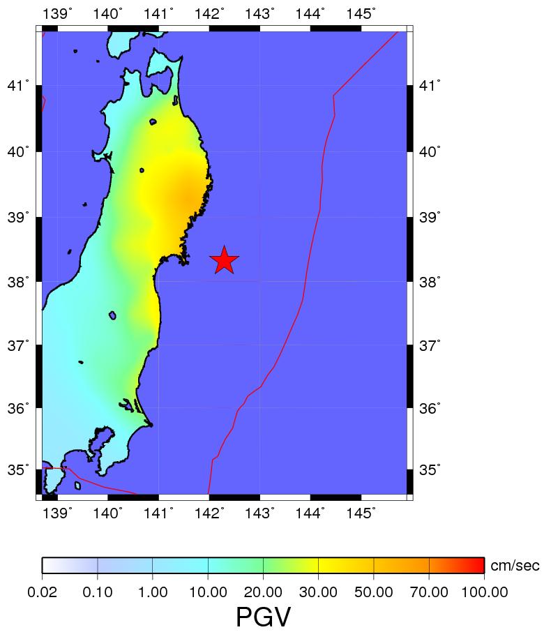
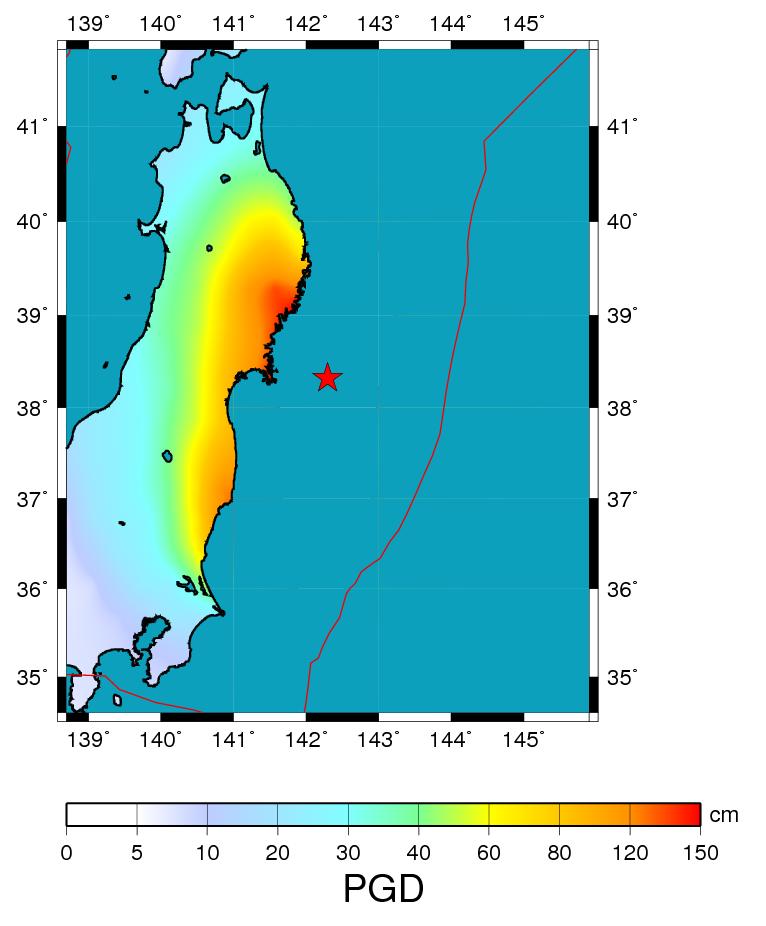
The magnitude 9.0 Tohoku earthquake on March 11, 2011, which occurred near the northeast coast of Honshu, Japan, resulted from thrust faulting on or near the subduction zone plate boundary between the Pacific and North America plates (USGS). The location, depth, and focal mechanism of the March 11 earthquake are consistent with the event having occurred on the subduction zone plate boundary. Modeling of the rupture of this earthquake indicate that the fault moved upwards of at least 20 m, and slipped over an area approximately 300 km long (along-strike) by 170 km wide (in the down-dip direction). The teleseismic inversion revealed a complicate rupture process with maximum slip close to 33 m. The map showing the projection of the slip and the synthetic peak ground displacement map show that parts of the coastal zone were up-lifted more than 1 m result which is also shown by other studies
Slip model by Agalos A. email: aagalos@geol.uoa.gr, aagalos@noa.gr
Teleseismic Bodywave Modeling by Alexandra Moshou email: amoshou@geol.uoa.gr
----------------------
Focal Mechanism Solutions of Honshu Japan (source Nied, F-Net)
With Yellow Circle the earthquake's epicenter
Focal Mechanism Solution Retrieved from Teleseismic Bodywave Modeling
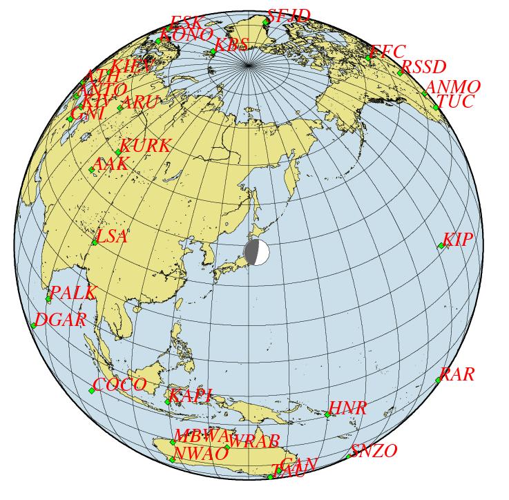
Stations at teleseismic distances whose data
were used in the slip inversion process
Slip model calculated from teleseismic inversion
Horizontal Projection of the Slip model
(plotted using Google maps)
Synthetic PGV and PGD Maps based on the calculated Slip model
References
1) Agalos A., Papadimitriou P., Makropoulos K., 2008. Rupture Histories of Strong Earthquakes. 31st General Assembly of the European Seismological Commission, held at the Creta Maris
Conference Center, Hersonissos, Crete Greece, Book of Short papers, p 9-16
2) Bouchon Michel, 1981. A simple method to calculate Green s functions for elastic layered media. BSSA, 71, 4, 959-971.
3) Hartzell S. H., and Heaton T. H., 1983. Inversion of strong ground motion and teleseismic waveform data for the fault rupture history of the 1979 Imperial Valley, California, earthquake. BSSA, 73, 1553_1583.
4) Mendoza C. and Hartzell S., 1999. Fault-slip distribution of the 1995 Colima-Jalisco, Mexico,Earthquake. BSSA, 89, 5, 1338-1344.
5) Wessel, P. and W. H. F. Smith., 1991. Free software helps map and display data, EOS Trans. AGU, 72, 441.
6) Moshou A., Papadimitriou P. and Makropoulos K.,2007. Teleseismic Body Wave Inversion. Proceedings of the 11th International Congress Athens, May 2007
7) Moshou A., Papadimitriou P., Makropoulos K., 2008. Waveform Inversion using Teleseismic and Regional Data for Earthquakes that Occurred in Greece. 31st General Assembly of the European
Seismological Commission, held at the Creta Maris Conference Center, Hersonissos, Crete Greece, Book of abstracts, p 95.
GDSN Waveforms downloaded from Iris.