A multidisciplinary in situ investigation on the physics of crustal deformation: The Gulf of Corinth Deep Geodynamic Laboratory1999 - 2001Project proposal of the Rock Mechanics Laboratory |
 1. Introduction: Fluids and faults
The goal of this project is to develop an in situ laboratory for obtaining data on the physics of earthquakes and, more generally, on fault mechanics. Particular emphasis will be placed on documenting the role of fluids on fault behaviour and the role of faults on fluid flow in an active rift.
The fact that fluids play an active role in earthquake rupture processes has long been recognised, either from geological observations on exhumed fault material (Sibson, 1992, 1994) or from physical considerations, in particular the lack of anomalous heat flux along the San Andreas fault (Lachenbruch and Zoback, 1992). But very few data are available concerning hydrological response to seismic excitation. They all involve surface, or subsurface observations (Roeloffs, 1988). No data has ever been recorded in active faults during earthquakes. Further, the hydrologic properties of faults remains poorly documented, even if some data starts coming out from recent investigations on core samples collected within the fault associated with the Kobe earthquake (Naka et al., 1998).
Surface hydrological observations (Muirwood and King, 1993) together with recent SAR deformation images obtained after the Landers earthquake (Pelzer et al, 1998) suggest that fluid flow associated with earthquakes may affect very large domains for long periods of time. But Pelzer et al’s considerations come from satellite observations of deformation. No direct hydrologic data are available. In order to document the proposition that earthquakes involve large-scale pore pressure variations, the idea is to set up in a seismically active zone a set of measuring points at various depths for monitoring pore pressure variations.
Although fault healing is well known to occur because of scaling, depending on pressure and temperature conditions as well as on the mixing of fluids with various origins (Boulčgue, 1997), its consequences on the rate of change in permeability as well as on the strength of the fault are not well documented. This comes mainly from the lack of data on the in situ conditions with respect to temperature, pressure, flow rate, morphology of the interconnected pore space and its relation to the chemical composition of circulating fluids. So, one of the main objectives of this project is to provide data on in situ flow conditions, below, within and above a recently activated fault. Furthermore, plans are to provide means for recording continuously the pore pressure before, during and after an earthquake within a fault zone and around it.
Results from the Parkfield experiment in California (Nadeau and Johnson, 1998) have shown that downhole seismic recording provides the possibility of detecting much smaller events than standard surface recording techniques. The large data sets on microseismic activity gathered at Parkfield during the last 10 years has shown the existence of asperities which slip apparently at recurrent times possibly linked with fluid diffusion. The question arises as to whether this is specific to the San Andreas Fault system or whether it is a characteristic of most fault behaviour.
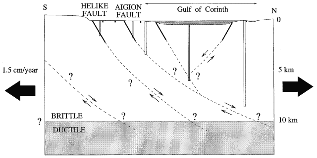
In order to answer these questions, it has been proposed to develop a deep in situ laboratory so as to gather data on earthquake sources and on fault mechanics. The most suitable place in Europe for such a laboratory is in the Gulf of Corinth because of its active tectonics (figure 1).
Figure 1 : Development of the Deep in situ Geodynamic Laboratory in the Gulf of Corinth : Plans are to installl in increasingly deep boreholes various sensors for documenting the relationship between fluids and fault mechanics.
2. The Gulf of Corinth Deep Geodynamic LaboratoryThe Gulf of Corinth is presently the fastest opening continental rift in the world with an opening rate somewhere between 10 and 15 mm/y and the tilting and uplifting of its southern shore at a rate which reaches locally 1 mm/y (Armijo et al., 1996). This fast opening is associated with a shallowly northerly dipping seismic zone located at depths ranging from 6 to 9 km. Five events of magnitude larger than 6 have been observed in this region within the last 30 years Comparison between GPS observations (Kahle et al., 1996) and cumulated seismic activity shows some discrepancy which may be attributed to non seismic deformation in the upper 4 to 5 km of the crust (Briole, 1999). Yet the significance and the mechanics of this non-seismic deformation remains to be documented.
Ten years of multidisciplinary observation and collaborative research in the Gulf of Corinth, supported in particular by EC programs, have allowed the selection of a target area (Bernard et al., 1998). It is located on the normal fault system close to the city of Aigion, which is one of the most seismically active areas of the Euro-Mediterranean region (see figure 2). The city of Aigion itself was struck by a magnitude 6.2 earthquake in 1995.
An ICDP (International Continental Drilling Program) supported international workshop, held in Athens in October 1997 (Cornet et al., 1998), helped mature this idea. Now the project of developing a Deep Geodynamic Laboratory in the very active rift of Corinth has been endorsed by ICDP and some funding has been obtained for setting up a local permanent sub-surface seismic network in the Aigion-Eratini area. A long term, multiphase project has been defined. Each phase, of 4 to 5 years duration, involves increasingly deep boreholes (1 000 m , 2500 to 3 000 m onshore, 6 000 m offshore, 8 to 10 km onshore), and, correlatively, increasingly deep in situ continuous observations.
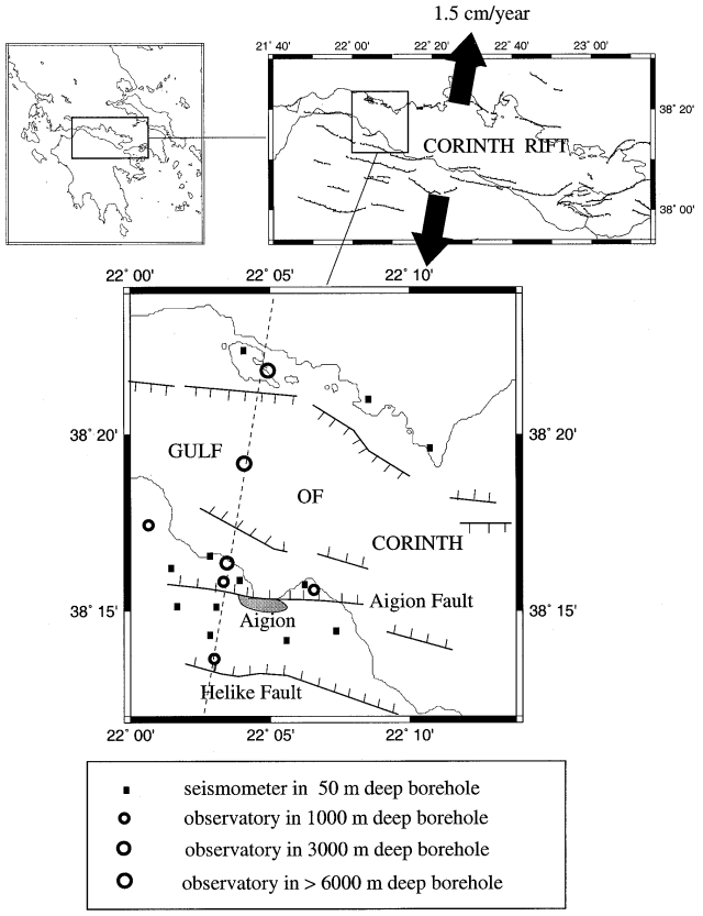
Figure 2 : Location and instrumentation of the Gulf of Corinth Deep Geodynamic Laboratory
3. Present activity: Instrumenting, on shore, from ground surface down to 1000 mOnshore, near Aigion, two active faults can be investigated, the Aigion fault and the Helike fault. The Aigion fault is relatively short (less than 10 km) but it has been reactivated in 1995 by a magnitude 6.2 earthquake. Very little evidence of surface deformation was mapped after the event. Hence it is anticipated that the rupture front died out progressively as it got toward the surface. One of the goals of the project is to try to document possible variations in fault hydraulic characteristics as one gets closer to ground surface. The much longer Helike fault (more than 50 km) has not been activated since 1861 when it gave rise to an earthquake of magnitude somewhere between 6.5 and 7. Hence it is anticipated that the healing process is quite developed in that fault.
This area has been chosen for installing downhole seismic sensors so as to determine whether the apparent lack of seismic signals in the upper 4 km is linked to attenuation effects or whether indeed no signal is generated within this depth range. In addition, some continuous GPS stations are being deployed so as to monitor precisely the deformation process of this sector.
It is planned to document the hydraulic properties of both the Aigion and the Helike faults so as to investigate the consequences of healing. This will be done by drilling through the faults first at a depth of 1000 m. The boreholes will provide means to retrieve hydraulic, mechanical, geochemical and geological data, thanks to logging, coring and in situ measurements (stress measurements, vertical and oblique seismic profiles, temperature profiles). Evidence for repeated breakage and sealing of cracks and veins in the cores will be looked for, and interpreted in terms of successive earthquake ruptures. These results will be confronted to observations retrieved from fault trenching at ground surface.
Because one of the main goals of this in situ laboratory is to document the faults hydraulic characteristics and their variation both in time and space, the sites will include two additional boreholes intersecting the strongly dipping faults around a depth of about 400 m. This will make possible running hydraulic interference tests coupled with chemical tracers so as to characterise the permeability of the fault systems and to monitor its possible variation in time.
A preliminary site reconnaissance will be conducted with seismic and electromagnetic profiles in order to identify precisely the geometry of the faults. These data, correlated with logging, borehole seismic profiles, core data, and the results from monitoring the microseismic activity will help obtain an accurate 3D understanding of the velocity field of the site together with a precise description of the fault geometry and its variation with depth. This is one of the key questions raised by the understanding of the rifting activity around the Gulf of Corinth : Is the observed low dipping seismic zone the result of listric faulting or does it result from a dense pattern of steep dipping normal faults and their antithetic conjugates. If listric faulting occurs, it has been proposed to link fault dip variation with depth with changes in material properties. Accordingly accurate determination of the fault zone mechanical properties will be conducted in the laboratory thanks to the cores retrieved from the wells.
4. Project: Instrumenting the Seismogenic zone by offshore drillingThe program to be run in the 1000 m deep onshore boreholes will constitute a very useful learning process and will help improve our understanding of the downhole fault geometry. But it will not provide data from the seismogenic zone and thus will fail answering the precise questions on the physics of earthquake faulting. It is only once the seismogenic zone has been instrumented that answers to the exact role of fluid on the dynamics of rupture processes will be documented. Also, is only through in situ measurements that the stress state and the temperature field will be evaluated. Further, the determination of the mechanical properties of the material required for modelling the rift opening process can only be obtained from cores collected at the right depths. Analysis of the borehole failure processes that are likely to occur at those depths will help further constrain the constitutive equations of the geologic materials encountered at those depths.
It is anticipated that an intermediate depth (2500 to 3000 m) borehole may be necessary to further refine our understanding of the fault geometry . But it is only when a 5 to 6 km deep well is drilled offshore that it will be possible to gather the required data for advancing our understanding of earthquake mechanics. Hence our proposition to ODP to perform the required deep well and to help deploy offshore seismometers and possibly downhole instruments in shallow wells (in the order of 500 to 1000 m) in order to obtain better constraints on fluid flux and location of seismic activity in this fast opening rift.
References